The ancient geography of the Mediterranean Basin has been profoundly changed by sea level rise following the Late Glacial Maximum. This global event led to the retreat of coastlines as a result of water locked up as ice – or that is the way it is usually explained and visualised by scientists and lay-people alike. Frozen water led to the emergence of vast areas of continental shelf and islands that are now submerged features on the sea bed. Sceptics might not be so certain but the idea underlies a paper in the Journal of Archaeological Science: Reports 3 (2015) page 398-407, by Emanuele Lodolo and Zvi Ben-Avraham – see www.sciencedirect.com/science/article/pii/S2352409X15300535
Most sea level maps of the Mediterranean appear to show lots of islands in the Late Glacial Maximum which do not exist nowadays. It is assumed sea levels rose rapidly after the shrinking of the ice sheet over the northern hemisphere – so how much of this is assumption and what bit is fact is a matter of faith. Did all those islands really exist – or has somebody come along with a measuring stick and said the global sea level was at such and such a low so therefore this island and that ridge was above water – and must have been submerged in the rising waters of the early Holocene period. This idea fix is at the core of this article so you need to keep blinking when reading it otherwise you will be taken in by the logic. The whole idea of rising sea level in the Mediterranean is an interesting one as it effects the Black Sea too. Some years ago a couple of American researchers came up with the idea the flooding of the Black Sea (to its current level) was a catastrophic event that is preserved in the Bible as the Flood of Noah (or something along those lines). It also involved the stars in the sky and precession. As always when innovative ideas are floated, and when the Bible is used as a witness, the detractors very quickly come out to throw cold water at the bright new idea. They claimed the Black Sea was subject to an increase in water in the Late Pleistocene/early Holocene period. This flood was many times greater than the flood that was being dated around 5000BC (and by some a tie up with the 6200BC event seemed likely). Trevor Palmer discussed the Black Sea situation in one of the SIS journals, possibly during a book review. The flood was supposed to have turned a freshwater lake into a body of water with access to the salt water of the Mediterranean, and it involved a catastrophic breach of the Bosporus – hence the idea of linking it with the 6200BC event (which becomes more dramatic and more global the further you set your sights). Taking a neutral stance, and being a bit wishy washy perhaps, we should look at the Black Sea as having experienced periodic changes in level – just like the sea. The problem is what caused the changes to occur.
The article above claims to have used the local sea level curve and come up with a date of submergence at 9350 years ago (over a thousand years prior to the 6200BC event). Hence, we are looking at a known event (8000 years ago) as opposed to a conceptualised event (estimated by non-provable computer graphics) at over 9000 years ago (as we have a +/- 200 year qualification attached to the 9350 figure). You will have to read the pdf link for yourself, which supplies the full article.
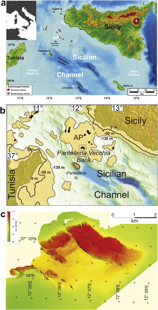
So, it begins by the assumption a lot of ocean water was locked up as ice and therefore this lowered sea levels right across the globe – and not just in areas that have been subject to study. Hence, we can only proceed on the further assumption that lower sea levels existed in the Mediterranean in the Late Glacial Maximum, as that is how the authors proceed. This affected the Sicilian Channel as much as anywhere else, an area with a number of shoals (or banks) and some of these formed an archipelago of several islands south of what is now Sicily (see map)
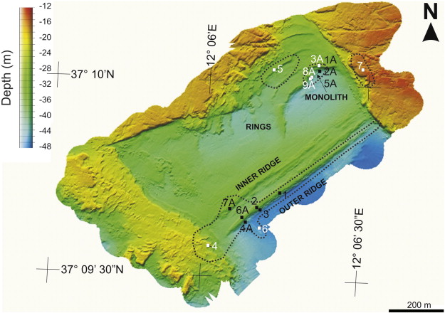
 One of these, Pantilleria Vecchia Bank, 60km south of Sicily (in the direction of Tunisia) has been extensively surveyed using geophysical and geological methods. It is composed of two shoals connected by a narrow ridge which encloses an embayment. Such a location, it is theorised, would be attractive to humans.
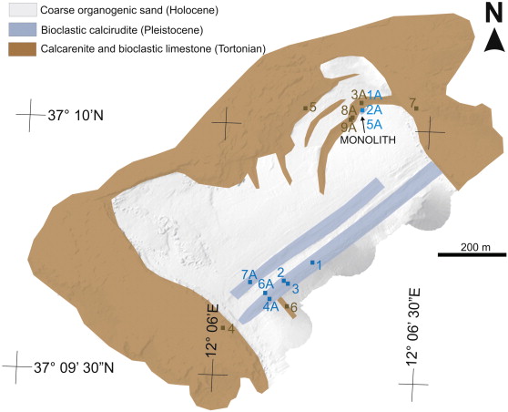
The article goes on to say that a 12m long orthostat situated on the embayment appears to be man made. It has straight edges and sides and three holes of uniform dimensions and is under 40m of water. That is not a great deal when you realise the Dogger Bank is at a similar depth (roughly) and we know that was above water prior to 6200BC. The orthostat is broken into two parts and has been carbon dated by shells encrusted on it to the Late Pleistocene or Early Holocene. It seems, contrary to what I just wrote, it has been extracted from the rectilinear ridge between the two shoals and encompassing the embayment, so we may have a situation whereby critics will home in and use as a stick to bludgeon their argument.
According to the authors this represents evidence of significant Mesolithic (early Holocene) activity in the area. They say they used high resolution bathymetric surveys on the Pantilleria Vecchia Bank and the Talma and Vogel (1993) calibration method for C14 (and they appear in the bibliography) and this was used to date a rock sample from the orthostat. From the data analysed they reach the conclusion the orthostat was not a natural feature but was man made. It was cut and extracted as a single stone from the ridge and transported for erection to where it was found. There follows a discussion on the reliability of the local sea level curve and date of submergence. Apparently, the area is also tectonically stable which rules out subsidence. They say it can only have been submerged by rising sea levels.
They then go on to compare the orthostat to the stone monuments of Gobekli Tepe in SE Turkey – which is dated even earlier. Gobekli Tepe has revolutionised the Mesolithic period as non farming people were able to erect a massive monument on a high point overlooking the Syrian Plain. The purpose of the orthostat on the embayment in the Sicilian Channel is unknown – but it's a big stone and the stones used at Gobekli Tepe were big too. The authors are therefore placing on a hunter gatherer society a lot of skills otherwise not attributed to the Mesolithic period – knowledge, the ability to cut and dress stone and technology of a more advanced kind (than usually imagined). However, humans adapt and these human were perhaps fulfilling some need that involved erecting a large stone 12m in height – somewhere (and not necessarily where it was found).

 The claim is that these people were far from primitive and they use the Gobekli Tepe people as a reference point. The same attitude prevailed in the Horizon programme, 'The First Britons' which was all about the Mesolithic inhabitants of the British Isles (as it included the spread of farming, even as far north as the Shetlands). All this will be argued over in the coming years but it represents an extreme paradigm shift. The old class based attitude that Mesolithic people were backward and technologically ignorant is fading fast – and the chap taking soil cores in the Horizon programme was quite right when he said these people were as intelligent as we are nowadays and therefore equipped to innovate. We don't know what the motivation was to construct with large stones but people did – and continued to do so. Archaeology is in the process of proving that humans in the past were more adept than modern day people thought they were – and if they lived through catastrophic episodes they may well have been much more positive than a lot of people alive in the modern world.
