At https://phys.org/print417760283.html … scientists have constructed 'in detail' the collapse of the Euroasian ice sheet at the end of the Late Glacial Maximum and it final moments involved the flooding of the English Channel 10,000 years ago. We are told the ice sheet was massive, stretching from the tip of SW Britain to Franz Josef Land in the Siberian Arctic. We are also told it lowered global sea levels by 20m. As it melted, and collapsed, it caused severe flooding across Europe – and a dramatic rise in sea levels. The research is published in Quaternary Science Review (June 2017) and used modelling techniques to reconstruct what happened between 15,000 and 13,000 years ago. This was the warm interval between the end of the LGM and the onset of the Younger Dryas. During this time the ice sheet is said to have lost 750 cubic km per year. At peak rates of ice loss it was 3000 cubic km a year. A cubic km of ice contains one thousand million tonnes of water (1,000,000,000) – which when multiplied by 3000 gives you some idea of the volume of flooding involved in the melting at the end of LGM. Lots of water. What would have happened if there had been a pole shift, or axial tilt? The flooding event would have been much quicker, I suppose, and pretty well devastating to all wildlife, and humans, in the process.
The amount of ice may actually be over calculated as the area of the ice sheet is determined by such things as moraines and other geological formations, as well as rock scouoring etc. They assume the ice melt was uniformitarian in nature – gradual in common lingo. This is a basic assumption of the modelling process. In spite of that they have identified Meltwater Pulse IA as a period of very rapid sea level rise that took place in a period of around 400 years, very quick in a uniformitarian scenario. Global temperatures were rising they say, although ice cores indicate this took place much quicker, in tens of years rather than hundreds. The we learn that this study has a climate change angle as they add that this is ten times the current rate of ice loss in Greenland and Antartica today. What a remarkable thing to put in what was otherwise a precisely worked out model, with careful arithmetic and calculations. Antarctica has been gaining ice over the last 20 years and it is only the bit that sticks out, the West Antarctic peninsular, that loses ice (and regains ice too) as a result of being in the way of the movement of warm water from the Pacific and Indian oceans into the South Atlantic (in the wake of El Nino events in the tropical Pacific).
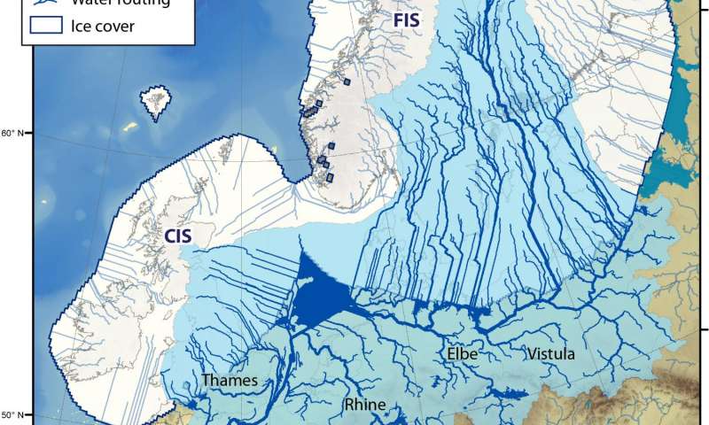
We are left to assume these are not just uniformitarian numbers, crunched on a a number of assumptions, but include a dollop of climate change misinformation. In other words they could very well have exaggerated the amount of ice that existed during the LGM, without batting an eyelid. One interesting image (below) …
 … shows all the rivers of Europe emerging from a large meltwater lake at the bottom of the ice sheet. These rivers fed into the Black Sea, the Mediterranean, and the Atlantic, and we may expect to find evidence that, for example, the Black Sea increased in size (and indeed it did). The uniformitarian modelling went on to show that ice melt continued down to at least 10,000 years ago, when Ireland became an island and the Channel formed between France and England. This is conjecture and only possible under an extremely gradual process. If ice melt had been dramatically rapid at the end of LGM they have a problem as what might then have caused jumps in sea level between 15,000 and 8,000 years ago – or even at 5000 years ago.
