At www.sciencedaily.com/releases/2017/10/171027085747.htm … scientists still explain land features on Mars by water flow. Experiments seem to show that because of Mars thin atmosphere during warm temperature periods water on the surface may actually boil – which is then able to move large amounts of sand and sediments. This idea has been dreamed up because the geology of Mars is done by Earth geologists where water is thought to shape landscapes and be able to move sediments around. Geologists on Earth have transferred their theories to Mars – and water must play a role (even if water is available in insufficient amounts). Hence, some novel ideas are used to explain landform changes – to account for sand dunes, gullies, and slope linaea (which occurs as a result of sediment transportation down a slope). What is behind these geological processes if not water?
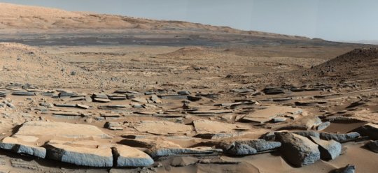
Robert comments on the caption to the image below …
 … a view from the Kimberley formation on Mars taken by Curiosity Rover. The strata in the foreground dip towards the base of Mount Sharp indicating flow structure toward a basin that existed before the larger bulk of the mountain was formed. Robert asks, Curiosity Rover landed in an impact crater – Gale. If water was able to flow towards Mount Sharp (Aeolis Mons) before the bulk of the central peak formed – just how long do impact events last? I am supposing the geologists don't think Mount Sharp was part of the impact event – but Robert does. What do you think?
